Pages

Wednesday, January 29, 2014

Monument Valley

I suspect there is much more to see at Monument Valley than we saw on our visit of September 26th. There is a 17-mile unpaved road through the park, but it's very rough and recommended for only high-profile vehicles. We saw several regular passenger vehicles attempting the route, but we watched their progress long enough to know that we didn't want to try it. Tours are available for $60 per person, but we felt we had seen enough on our drive down from Blanding that it wasn't necessary to take the tour.

This is the awesome view from the balcony of the Visitor Center.

Following are closer views of the three monuments pictured above:


Another view from the Visitor Center

Looking at a portion of the 17-mile unpaved road.

After leaving the park, we took a little drive through the nearby countryside.

Free range horses near Monument Valley

Then, as we drove back to Blanding, we took more photos of the strange, but beautiful, landscape:


Sunday, January 26, 2014

Driving to Monument Valley

The next stop on our Trip West 2013, was Blanding, Utah, from which we would drive to Monument Valley, about 75 miles south.

Monument Valley is a Navajo Tribal Park (30,000 acres), established in 1958, and located on the border of Arizona and Utah within the 16-million-acre Navajo Reservation. Over the years, because of Monument Valley's unique sandstone formations, the park has been the setting for more Western movies than any other site in the United States.

Following are pictures of some of the beautiful rock formations that we saw on September 26th, on the drive from Blanding to the official entrance of the park. Our route took us through two small towns...Bluff, Utah and Mexican Hat, Utah.

"Navajo Twins" at Bluff, Utah

Cow Canyon Trading Post at Bluff, Utah

This rock formation was just outside of Mexican Hat, Utah

Can you see how the town got it's name?

Continuing on down the road toward Monument Valley, we saw more and more beautiful and interesting rock formations:


I'll have another post, with photos from Monument Valley and the surrounding area in a few days.


Thursday, January 23, 2014

Canyonlands Needles District: Landscapes

These photos are again from our visit to the Needles District of Canyonlands National Park in Utah, on September 25, 2013.

We spotted this Moonflower shortly after leaving the Cave Spring area.

We also saw this interesting rock formation in the distance.

Later, we came upon a sign telling us that the rock formation is known as Wooden Shoe Arch.

This is a section of the Needles that are visible from Elephant Hill Spur Road.

Here's a little closer look at one section of the panorama shot above.

We almost drove right past that Needles overlook on Elephant Hill Spur Road, without taking any pictures, because the Needles were so far away. We thought we'd just wait until we had closer views. But, the old adage of "a bird in the hand..." came to mind so we stopped for a few shots. As it turned out, that was the only time we saw the Needles for which this section of Canyonlands is named. Apparently, other views are possible only by long hikes or off-road vehicles.
 
The next three photos were also taken along the Elephant Hill Spur Road:


And the final four photos were shot near where the road ended at Big Spring Canyon Overlook:


We enjoyed this part of Canyonlands National Park, but we were disappointed in not being able to see some of the beautiful places pictured on the promotional information. When I asked at the Visitor Center, they told me that many of those features can be viewed only after lengthy hikes or by off-road vehicles.
 
Still, we definitely enjoyed the beauty of the landscapes and our hike on Cave Spring trail.
 
Next up on our Trip West 2013 will be Monument Valley. Stay tuned.


Monday, January 20, 2014

Canyonlands Needles District: Cave Spring Trail

One of the first things we did on our September 25th visit to the Needles district of Canyonlands National Park in Utah was to take a short hike on the Cave Spring Trail.

Doug and I both enjoy stories of the Old West, and we have read almost every book written by Louis L'Amour. We knew we had to take this hike when we saw that there was, not only a spring, but an old cowboy camp on this trail.

Canyonlands was extremely remote when livestock were first brought into the area around 1890. Just to get to the pastures often required a ride of two or three days, and cowboys frequently had to stay in the backcountry with the herd for months at a time. To make life a little more pleasant for the cowboys a series of camps were established throughout the area; and, in the Needles District, the Cave Spring Camp was one of the most important. The camp is still largely intact and  offers a fascinating insight into what a cowboy’s life was like in the early 1900s. 

The trail took us around a large rock formation that was narrower at the bottom than at the top, resulting in a large overhang, with alcoves underneath that created cave-like spaces. It was sort of like walking under a large mushroom.
 
Cave Spring Trail

Outside of the Cowboy Camp

Part of the inside of the camp

This picture shows the large overhang sheltering the camp.

This grain bin was situated near the cowboy camp; and there was actually grain in it.
I half expected a rat to scurry out of it when we lifted the lid. Thankfully, that didn't happen!

Looking back toward another small cave.

Cave Spring is one of the area's few year-round water sources.

When we were there, it looked more like a seep than a spring.
Ferns grew on the rock wall above the spring.

This picture again shows part of that large rock overhang.
(It made for pleasant walking as it provided shade from the hot sun.)

Past Cave Spring, two ladders ascend to the slickrock above, providing panoramic views of canyon scenery. Doug climbed the first ladder, just to look around; but we decided to return to our car by the way we had come.

Doug at the top of the first ladder.


Friday, January 17, 2014

Canyonlands Needles District: The Entrance

On September 25th, we explored Canyonlands National Park, the Needles district. Most of the pictures I'm sharing today were taken along the road leading to the national park.

Church Rock is at the junction, where you turn to drive back to the national park.

These next photos were taken along the road that leads to the national park entrance:


This last shot was taken shortly after entering the park:

We had amazing weather on the entire trip, but it was quite windy on this day. The winds were gusting to 50 miles per hour! I'm glad I wasn't wearing contact lenses.

I'll have more from the Needles district in future posts. Until next time...


Tuesday, January 14, 2014

Arches: Sand Dune Arch & Delicate Arch

More from Arches National Park on September 24...

Sandstone Fins

This narrow, uphill path leads between two sandstone fins on the way to Sand Dune Arch.

Sand Dune Arch (and me)

It's always hot at Arches National Park. On this day, it was relatively cool...about 80 degrees Fahrenheit. But the sun is very intense, and there's almost no shade. When we got to the parking lot for Sand Dune Arch and Broken Arch, Doug and I split up. I went to Sand Dune Arch because it was closer. He followed the longer trail toward Broken Arch.
 
Because Sand Dune Arch is in a narrow space between two tall sandstone fins, it's like being in a cave...shady and much cooler. And the sand makes it seem like a beach. A young family was picnicking in there, letting their small children play in the sand. They were the only ones there when I entered. The young mother, seeing that I was alone, offered to take my picture.
 
At Sand Dune Arch, looking back toward the entrance, where Doug was approaching.

I'd been lugging my camera and a spare lens around all day. But, I decided to leave my wide-angle lens in the car and carried only my telephoto lens when I went to Sand Dune Arch. Well, since Sand Dune Arch is in a narrow place between sandstone fins, I couldn't get back far enough to get a decent shot, and I really didn't want to walk back to the car to get the other lens.
 
Fortunately, Doug was able to get this shot with the camcorder.

Broken Arch is not really broken. Its name comes from the fact that there is a large crack in the middle of its formation.

Broken Arch
Photo taken by Doug with the camcorder.
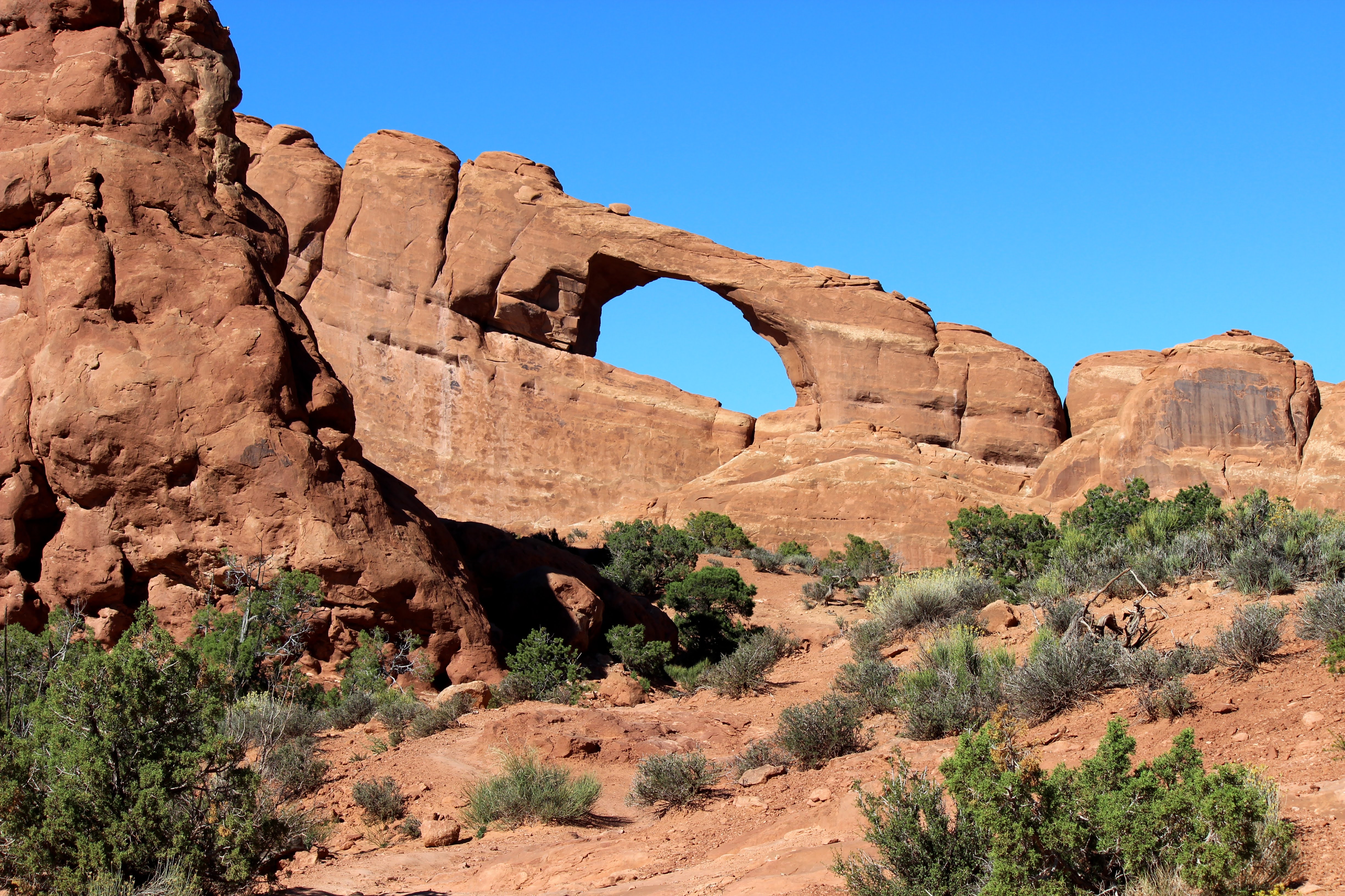
Skyline Arch

A view from the trail to the Delicate Arch overlook

Delicate Arch from Overlook

Delicate Arch from Overlook
 
This beautiful arch is much larger than you might think, as can be seen by how tiny the people look on the ridge and near the base of the arch.

Delicate Arch can be seen from below and photographed nicely if a long lens is available. There is a trail that leads to the base of the arch, but it's long and hot and can be slippery. It does provide great photo opportunities, though, with the LaSal Mountains visible through the arch. 
 
We took a shorter trail to an overlook that brought us closer to the arch but not to the base of it. Even that trail was difficult. It was an uphill climb on a hot day. I'm not sure I'd do that again. I think I could be satisfied with whatever shots I could get from below. A tripod and a long lens would surely be easier.

This wraps up my posts from Arches National Park. Next time, I'll share some photos from the Needles district of Canyonlands National Park.


Related Posts Plugin for WordPress, Blogger...