Pages

Showing posts with label Blue Ridge Parkway. Show all posts

Wednesday, May 02, 2012

The Blue Ridge Parkway, Part 3

Brown Thrasher

This Brown Thrasher should have been included in the previous post because it was near the end of our driving day on April 16, when we found him singing happily from the top of a dead tree at the Pine Tree Overlook. Brown Thrashers are a type of mockingbird, belting out the calls of a wide variety of other birds. This one had a wonderful repertoire and was giving us a excellent concert. He was startled away by the arrival of a large crow, but he returned to his spot in the dead tree as soon as the crow had left the area, picking right up with his mimicry of virtually every bird in the area.

There weren't many special features to enjoy on our second day's drive on the Blue Ridge Parkway, on April 17th, other than the scenic overlooks. The attractions that we had on our list to visit were all closed, not having opened yet for the season.

Although the facilities at Mabry Mill were closed, we we were still able to walk through the area and view the old buildings and equipment. The mill itself is very picturesque, situated as it is next to a small pond and reflecting in the water.

Mabry Mill

Since so many of the facilities along the Parkway were closed, we couldn't find restrooms. We wound up turning aside at Fancy Gap, NC. After using the restrooms at a gas station there, we went in search of a restaurant. Just past the bridge that led back onto the Parkway, there was an antique shop and a little deli. I think it was called Treasure Potts. Anyway, the daily special at the deli was a Monte Cristo sandwich, with chips and a pickle; and it was delicious. We may never be back in that area; but, if we were, we'd put that stop on our agenda.

The Parkway was closed between Mileposts 217 and 245, so we exited at Sparta, North Carolina. It was a little early in the afternoon to stop for the day, so we decided to drive on to Boone and spend the night there.

During the night, there were thunderstorms and heavy rains. As a result, there was fog on the Parkway the next morning, April 18th. Signs on the Parkway warn against traveling that road during fog, ice, or snow conditions; but we told ourselves that the fog would most likely clear up shortly. (We sometimes deceive ourselves.)

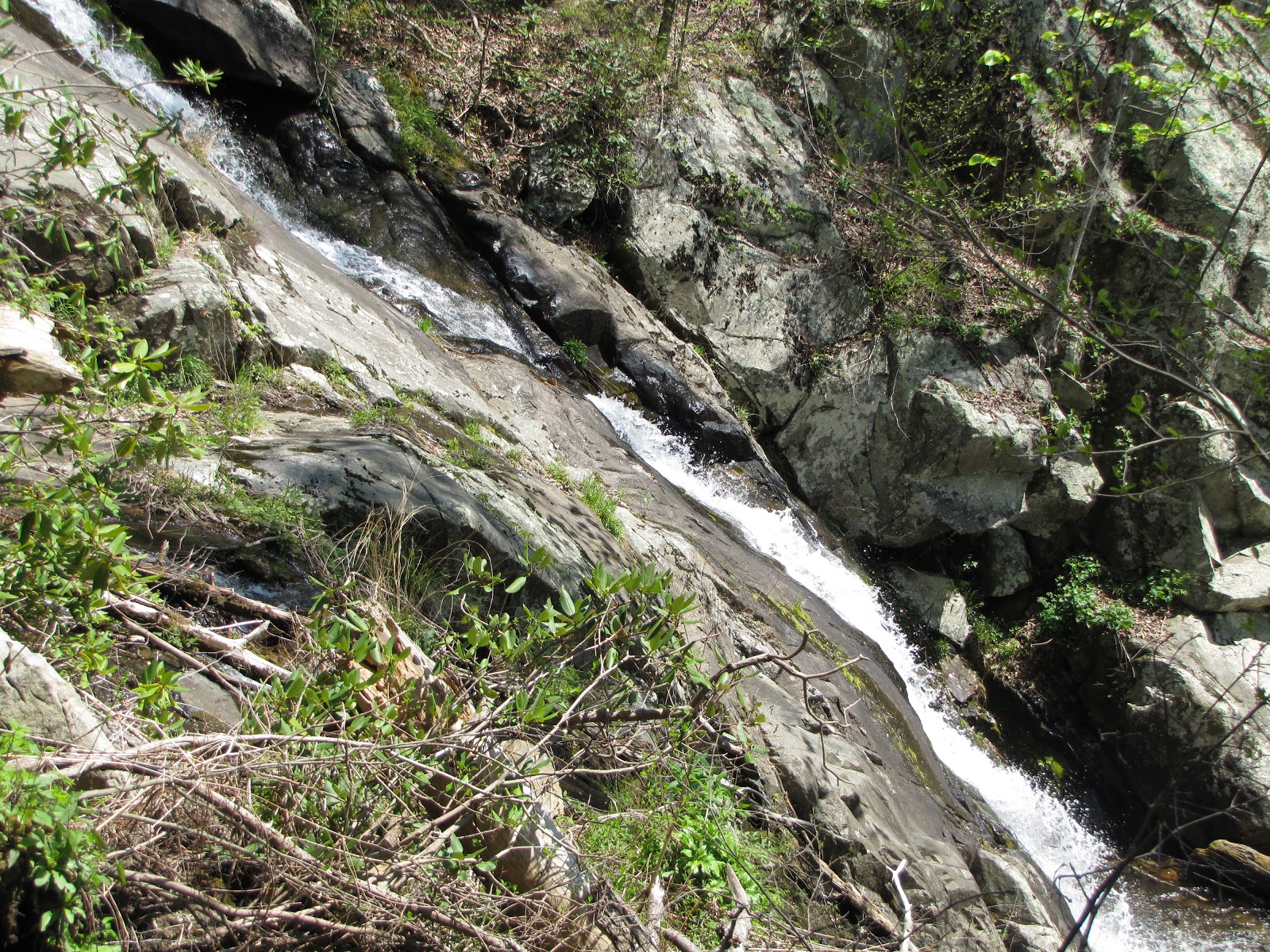
We entered the Parkway that morning at Blowing Rock, North Carolina. Initially, the fog wasn't too bad, so we kept going. The heavy rains of the night before had created waterfalls where there probably hadn't been waterfalls before. 

Cascade at Rough Ridge Overlook

Roadside waterfall near Linville, NC

But then the fog became pretty thick, making driving the winding road more difficult and the signs at the overlooks the only things to be photographed.

Glassmine Falls Overlook

This was the view as we exited a tunnel.

This was shot through the rain-spotted windshield, in an area where the fog had lifted a bit.

A wet wild turky scurrying off the roadway into the shelter of the woods

We decided to end our drive down the Blue Ridge Parkway at Asheville, North Carolina, even though it meant that we would miss the last 75-100 miles of its famous scenery. We left the Parkway at Asheville and headed for our rented cabin in the Smoky Mountains. Someday, we hope to cover those last miles of the Blue Ridge Parkway, from the other end.


Monday, April 30, 2012

The Blue Ridge Parkway, Part 2

After visiting the James River visitor's center, our next stop on the Blue Ridge Parkway was Fallingwater Cascades. The information I had was that it was 3/10 mile to the first cascade, with an option to walk further to more cascades if desired. Well, the temperature by then was in the eighties, and the walk was steep. And then, when we reached the cascade, it was hard to get any pictures of it because of the way the trail lay in relation to it and the underbrush between the two.

Doug on the trail to Fallingwater Cascades (You can see the cascades in the background.)

A closer look at Fallingwater Cascades

Dogwood blossoms on the Fallingwater Cascades trail

Butterfly on dandelion along the Fallingwater Cascades trail

After the hot hike back to our vehicle and its welcome air conditioning, we drove to Peaks of Otter Lodge, where we parked, walked around a bit, and rested for a few minutes on a bench by the lake.

Sharp Top Mountain at Peaks of Otter

Peaks of Otter Lodge

We had wanted to spend a night at Peaks of Otter Lodge, but the timing just didn't work out. It was mid-afternoon when we arrived there, and we decided to drive on a little further before stopping for the night. We wound up staying in Roanoke, Virginia; and it was ninety degrees Fahrenheit when we arrived in town. That's way to hot for April 16th.

Friday, April 27, 2012

The Blue Ridge Parkway, Part 1

After a day spent driving the Skyline Drive in Shenandoah National Park in Virginia, followed by three days driving the Blue Ridge Parkway in Virginia and North Carolina, we spent a week in the Smoky Mountains of Tennessee, in a rented cabin that had neither cell phone service nor internet service.

But I'm back now and will be trying to catch up on blog reading and commenting over the next few days. Please be patient with me.

My last post contained some highlights of our trip down Skyline Drive. Today's post will introduce you to the Blue Ridge Parkway.

Though not a national park, the Blue Ridge Parkway is a National Scenic Byway and is the most visited unit in the United States National Park System. Running for 469 miles, mostly along the ridge of the Blue Ridge mountain chain that is part of the Appalachian Mountains, the Blue Ridge Parkway connects Shenandoah National Park in Virginia with Great Smoky Mountains National Park in North Carolina and Tennessee. It's a winding two-lane road, with a maximum speed limit of 45 miles per hour but which is best traveled at a much lower average speed. There are many scenic overlooks, of course; but there are also many opportunities for getting out of your vehicle and exploring the area on foot.

This was our first trip on the Blue Ridge Parkway, and we decided to make it sort of a get-acquainted tour, rather than an in-depth exploration. That was just as well because we were actually traveling the route a little too early in the year. Many of the attractions and facilities had not yet opened for the season. So there was much that we didn't see. But what we did see was pretty impressive.

View from Ravens Roost Overlook

Sitting behind the wheel of a car for extended periods of time just wears Doug out. So we looked for things to do along the way that would allow us to get out and stretch our legs and enjoy the scenery up close and personal. One of those involved a short side trip to Crabtree Falls in Virginia.

Crabtree Falls (in Virginia)

Chimney Rock Mountain Overlook

Otter Lake Dam

IMG_4758_James_River
James River

The James River flows from the mountains through Lynchburg and Roanoke to the coast. It's the largest river in Virginia and, historically, one of the state's most important transportation corridors. A restored lock is on display at this site, providing an interesting look into the river's past.

James River Bridge (with a footbridge underneath the surface used by vehicles)


I hope you've enjoyed this introduction to the Blue Ridge Parkway. I'll have more to share in a future post.


Related Posts Plugin for WordPress, Blogger...