After a day spent driving the Skyline Drive in Shenandoah National Park in Virginia, followed by three days driving the Blue Ridge Parkway in Virginia and North Carolina, we spent a week in the Smoky Mountains of Tennessee, in a rented cabin that had neither cell phone service nor internet service.
But I'm back now and will be trying to catch up on blog reading and commenting over the next few days. Please be patient with me.
My last post contained some highlights of our trip down Skyline Drive. Today's post will introduce you to the Blue Ridge Parkway.
Though not a national park, the Blue Ridge Parkway is a National Scenic Byway and is the most visited unit in the United States National Park System. Running for 469 miles, mostly along the ridge of the Blue Ridge mountain chain that is part of the Appalachian Mountains, the Blue Ridge Parkway connects Shenandoah National Park in Virginia with Great Smoky Mountains National Park in North Carolina and Tennessee. It's a winding two-lane road, with a maximum speed limit of 45 miles per hour but which is best traveled at a much lower average speed. There are many scenic overlooks, of course; but there are also many opportunities for getting out of your vehicle and exploring the area on foot.
This was our first trip on the Blue Ridge Parkway, and we decided to make it sort of a get-acquainted tour, rather than an in-depth exploration. That was just as well because we were actually traveling the route a little too early in the year. Many of the attractions and facilities had not yet opened for the season. So there was much that we didn't see. But what we did see was pretty impressive.
View from Ravens Roost Overlook
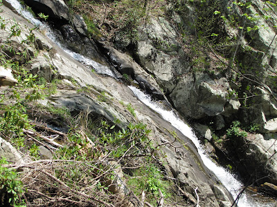
Sitting behind the wheel of a car for extended periods of time just wears Doug out. So we looked for things to do along the way that would allow us to get out and stretch our legs and enjoy the scenery up close and personal. One of those involved a short side trip to Crabtree Falls in Virginia.
Crabtree Falls (in Virginia)
Chimney Rock Mountain Overlook
Otter Lake Dam
James River
The James River flows from the mountains through Lynchburg and Roanoke to the coast. It's the largest river in Virginia and, historically, one of the state's most important transportation corridors. A restored lock is on display at this site, providing an interesting look into the river's past.
| James River Bridge (with a footbridge underneath the surface used by vehicles) |
I hope you've enjoyed this introduction to the Blue Ridge Parkway. I'll have more to share in a future post.


